Underwater noise: what are the challenges of achieving Good Environmental Status?
Our review identified the challenges of the UK achieving Good Environmental Status for underwater noise, making recommendations for decision-making
Read article

Coastal Infrastructure | Data and GIS Solutions | Design Support
Our study for the Environment Agency will improve understanding of coastal processes and the possible uses of existing land-based radar monitoring along the Lincolnshire coastline
An area of the Lincolnshire coastline, from Saltfleet to Gibraltar Point, faces significant coastal flooding risk, affecting 20,000 homes, 25,000 caravans, infrastructure, tourism, recreation and 35,000 hectares of agricultural land.
The Environment Agency’s Saltfleet to Gibraltar Point Strategy (SGPS) aims to manage the risk of flooding along the Strategy area. The current flood risk management approach involves an annual beach recharge, but ageing assets and climate change estimates suggest this is not a long-term solution.
To aid in determining a sustainable future approach, it is deemed necessary to monitor coastal changes and better understand the offshore processes affecting the Strategy area.
ABPmer has been appointed by AECOM, on behalf of the Environment Agency, to improve understanding of the coastal processes of the SGP area and provide technical advice and recommendations on the suitability of the existing land-based radar systems, which monitor intertidal elevations, subtidal features, waves and currents.
To improve understanding of coastal processes in the Strategy area, we are developing a desk-based conceptual model that demonstrates the impacting geomorphological and hydrodynamic forces.
The model is being developed through the input of traditional datasets - including LiDAR, bathymetry, topography and hydrodynamic data - and new datasets produced by innovative land-based radar monitoring systems by CoastSense. It aims to help identify and understand trends in coastal erosion and sedimentation including:
Where the sediment moves to and from
The rate and direction of movement
The volume of sediment change
The coastal processes causing movement
The existing CoastSense radar monitoring systems – comprising six masts along the Lincolnshire coast - provide remote, autonomous, 24/7 data collection throughout the Strategy area. They are intended to help identify more sustainable long-term approaches to flood risk management for the area.

One of the CoastSense radar masts on the Lincolnshire coast
The SGP frontage is one of the first locations where this innovative monitoring system has been trialled. As such, there is a requirement to understand:
The suitability of the radar products compared to traditional coastal monitoring methods for a range of flood risk management objectives
The extent to which the radar data supports and enhances the geomorphological and hydrodynamic activity
ABPmer’s suitability study will determine the accuracy, spatial and temporal variability and coverage, and frequency of the radar data compared to data from traditional monitoring methods. Practical considerations, such as the size of the radar data and any gaps, will also be explored.
The analysis will provide an understanding of whether the radar data can successfully identify whether - or to what extent - the beach is naturally recharging itself, and where to target beach nourishment and profile survey monitoring. This will inform recommendations on how the radar data can be used to support flood risk management decision-making of SGP, as part of the Environment Agency’s long-term strategy for the area.
Our specialists delivered interim report and accompanying webinar to the Environment Agency earlier this year. Following the conclusion of the analysis and delivery of the final report, the project is expected to be completed in Spring 2026.
ABPmer is a recognised authority in numerical modelling and metocean criteria, and is regularly called upon to provide technical input to engineering design that satisfies both consenting requirements and international standards. Discover how your project can benefit from our design support services.
Ready to discuss your requirements? Get in touch.


Our review identified the challenges of the UK achieving Good Environmental Status for underwater noise, making recommendations for decision-making
Read article
We are developing detailed oceanographic models to support the international athletes competing in the SailGP global championship. Learn more.
Read article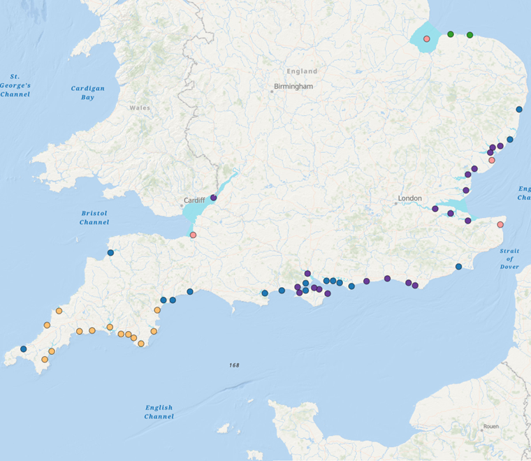
The Estuary Guide is a free, extensive, source of information about the UK’s estuaries. The Environment Agency has recently funded significant new updates
Read article